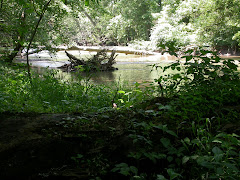
 One of my favorite ways to study Darby is using the software Google Earth.
 Google Earth is like flying in a spaceship. You start out viewing the earth from space, and then you can swoop down to view any place on the planet from a bird's eye view--usually to a height of a few hundred feet, depending on the resolution of the satellite photos the software taps for any given spot.
At right is a photo of the confluence of Big Darby and Little Darby at Georgesville in western Franklin County. It shows a rural mosaic of land uses, from the small town of Georgesville to woods and fields surrounding the creeks. Most of the land in view is part of Battelle-Darby Metro Park.
I can use the software to zoom in on any area of the watershed I want to see. This has allowed me to scout out promising areas to explore. It also gives me a great view of development as it spreads throughtout the area.
To sign up, just go to the Google home page and search "Google Earth." The first hit is where you sign up. This software free!

No comments:
Post a Comment